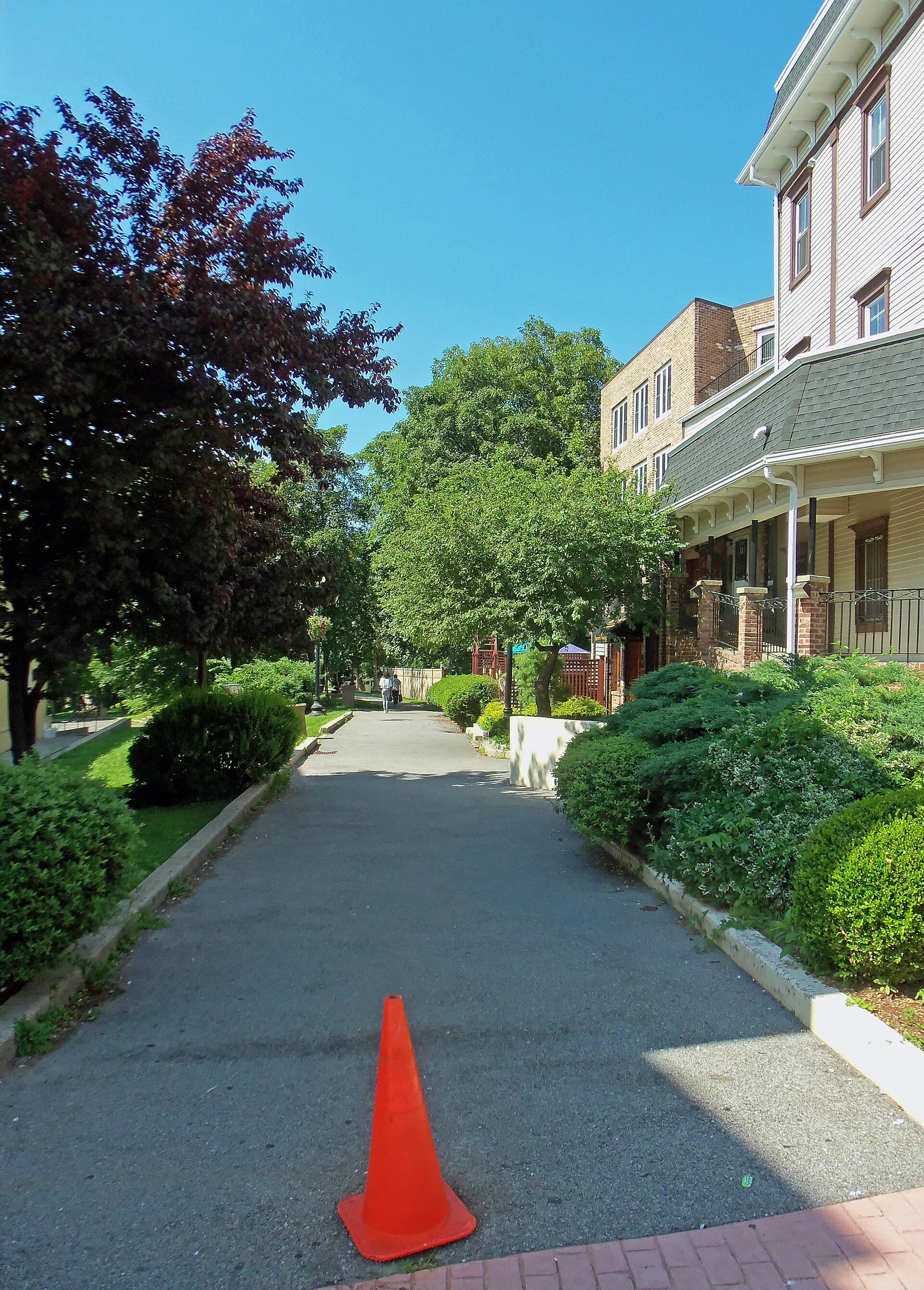
A quiet walking path follows the buried waterway that helped transform New York City.
The Old Croton Aqueduct carried water from the Croton River to Manhattan beginning in 1842. Much of its Westchester route is now a state historic park and trail. Visitors generally walk above the old conduit, not through an open underground tunnel.
That makes this forgotten place different from a roofless hospital or empty station. Its most important structure is often out of sight, while the route remains part of everyday life.
Why New York built the Old Croton Aqueduct
A growing city needed a more dependable supply of fresh water. Local sources could not adequately meet the demands of homes, businesses, firefighting, and public health.
Construction of the original aqueduct began in 1837, and water arrived in 1842. The system brought water roughly 41 miles from the Croton watershed toward Manhattan, where reservoirs stored and distributed it. NYC Department of Environmental Protection history
The route connected places now experienced separately. Reservoir sites, bridges, village paths, and surviving masonry all belonged to one system.
A long journey powered by gravity
The aqueduct carried water through a masonry conduit with a gradual slope. Gravity did the work that might otherwise be imagined as a chain of pumping stations.
New York State’s management plan describes the conduit’s horseshoe-shaped section and the related structures that helped the system function. Ventilators, waste weirs, and stream crossings were part of the route, not decorative additions. State park management plan
The engineering challenge was not just reaching Manhattan. It was maintaining the intended flow across a varied landscape.
A gentle grade can seem almost invisible to a walker. For water, however, small changes in elevation determine whether the entire system works. The route’s apparent simplicity conceals that careful planning.
What an old engineering drawing makes visible
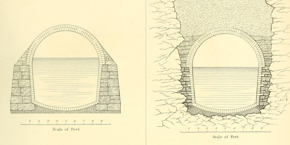
The 1845 drawing above shows cross sections of the aqueduct in earth and rock excavation. It is a useful companion to a walk because it reveals what the surface path usually hides.
Notice the rounded upper shape and the space intended for water below it. The drawing turns an abstract “underground waterway” into a structure with walls, proportions, and a relationship to the surrounding ground.
It also helps separate the historic conduit from a modern recreational tunnel. The aqueduct was designed to transport water, with access controlled for its operation and upkeep.
The featured photograph shows the route through downtown Ossining in 2011. Buildings and landscaping crowd close to the path, illustrating how the old alignment now passes through ordinary community spaces.
The people who kept water moving
Building the aqueduct was only the first task. Workers had to inspect and manage it after water began flowing.
The Friends of the Old Croton Aqueduct describe the work of keepers who watched the system, monitored conditions, and handled the practical responsibilities of an operating water supply. Operating the aqueduct
The Keeper’s House in Dobbs Ferry provides a surviving connection to that working landscape. It helps place people back into a story that can otherwise become entirely about stone, distance, and engineering. Friends’ history resources
A worthwhile visit looks for those small operational clues rather than expecting one enormous ruin. A ventilator or keeper’s building can explain more about daily use than a dramatic skyline photograph.
From water supply to historic park
New York’s water demands continued to grow, and a larger Croton aqueduct opened in 1890. The old system remained part of the city’s water history long after that expansion.
The original aqueduct ceased supplying New York City in 1955. That statement concerns its city-supply role; it should not be expanded into a claim that every related structure or local segment has had no later utility. New York City Municipal Archives
In 1968, New York State acquired a 26.2-mile portion of the corridor for the historic park. The original water route and the state park trail are therefore different lengths. New York State Parks
The new use preserved a line through communities that could otherwise have been harder to recognize. Walking became a way to keep the old infrastructure visible.
Planning an aqueduct walk
Choose a manageable section and use the current route maps. The trail passes through different settings, including wooded stretches, village centers, and road crossings.
The Friends’ visitor information covers the trail and Keeper’s House, including changing opening arrangements. Check conditions before traveling and allow for uneven ground, roots, mud, and interruptions where the route meets streets. Plan a visit
Do not enter underground chambers or maintenance openings. Any special interior access requires a specifically authorized program.
The pleasure of this route comes from learning to notice. A modest path can connect an engineering drawing, a surviving building, and a city’s need for water. Once that connection becomes clear, the walk is no longer just a strip of open space between houses.
Frequently asked questions
Do visitors walk inside the aqueduct?
Usually no. The public trail generally follows the route above the buried conduit. Interior visits require specific authorization.
How long is the Old Croton Aqueduct?
The original system ran roughly 41 miles. The state historic park preserves a 26.2-mile portion, mainly in Westchester.
When did it begin supplying New York?
Water arrived in 1842 after construction began in 1837. A larger aqueduct later supplemented the system.
Is the trail a single uninterrupted wilderness path?
No. It crosses varied landscapes, including communities and roads. Use current maps and choose a section suited to your plans.
Image credits
Featured image: Daniel Case, CC BY-SA 3.0.

Body image: F. B. Tower, Public domain.
