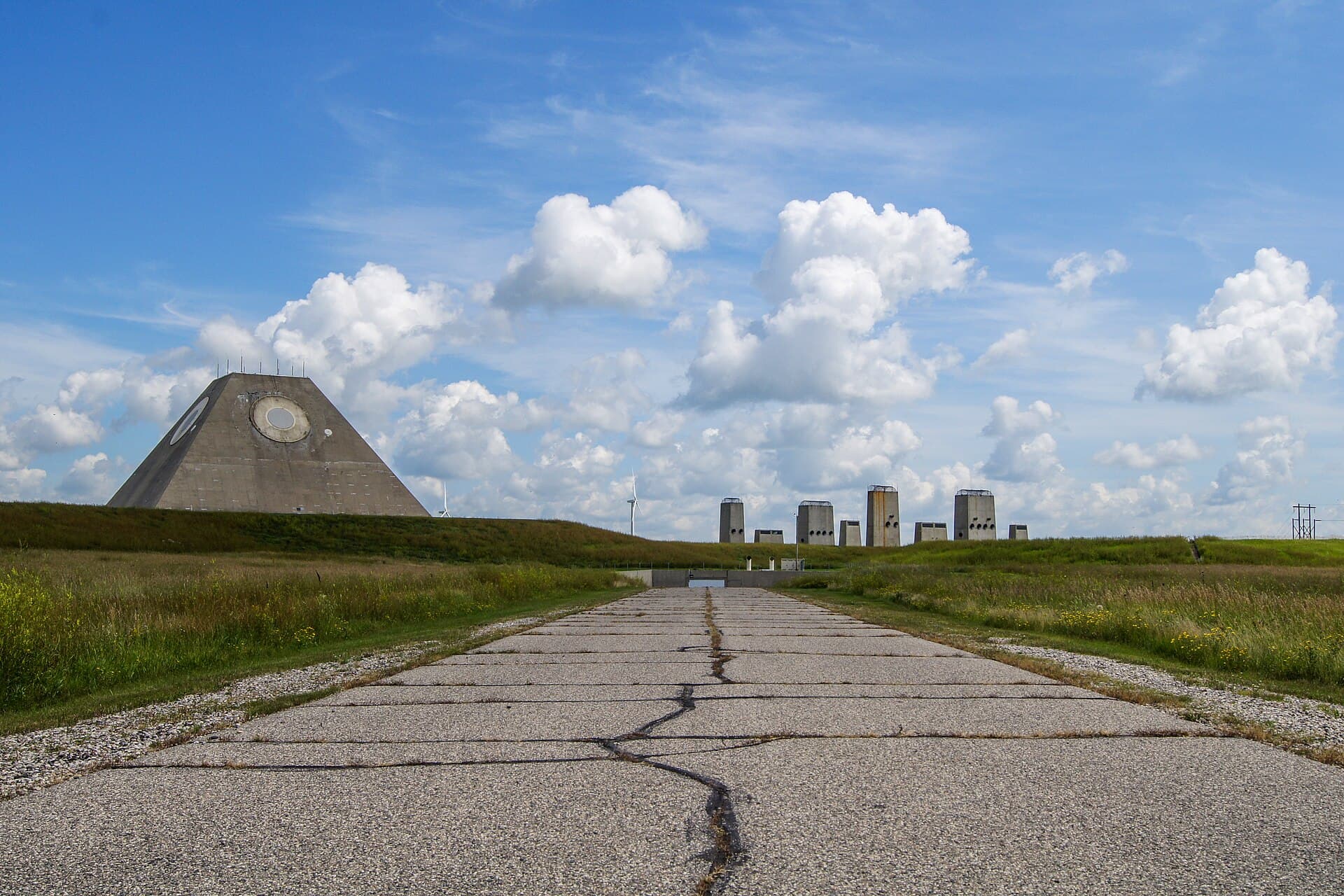
A concrete pyramid on the prairie once belonged to a nuclear defense system.
The Stanley R. Mickelsen Safeguard Complex near Nekoma, North Dakota, was built to protect American missile forces during the Cold War. Its striking radar building remains, but the original mission ended in 1976 after only a brief operating period.
The familiar claim that it worked for just one day oversimplifies the record. Army histories distinguish initial operation, full capability, political decisions, and actual shutdown. Those dates make the place more interesting, because its short life reflects a changing national debate rather than a machine that simply failed overnight.
What the Mickelsen Safeguard Complex was for
Safeguard was an anti-ballistic missile system. Its job was to detect and intercept incoming enemy missiles, helping protect the United States’ land-based nuclear missile force.
The Army’s history, Seize the High Ground, explains the program within the development of American missile defense. The North Dakota installation combined radar, computers, launch facilities, and interceptor missiles.
Its two interceptor types, Spartan and Sprint, were intended for different stages of an engagement. Both belonged to a defense concept that used nuclear warheads against attacking missiles.
That is an unsettling part of the story. This was not a shelter where residents would gather. It was a highly specialized military system built around the possibility of nuclear war.
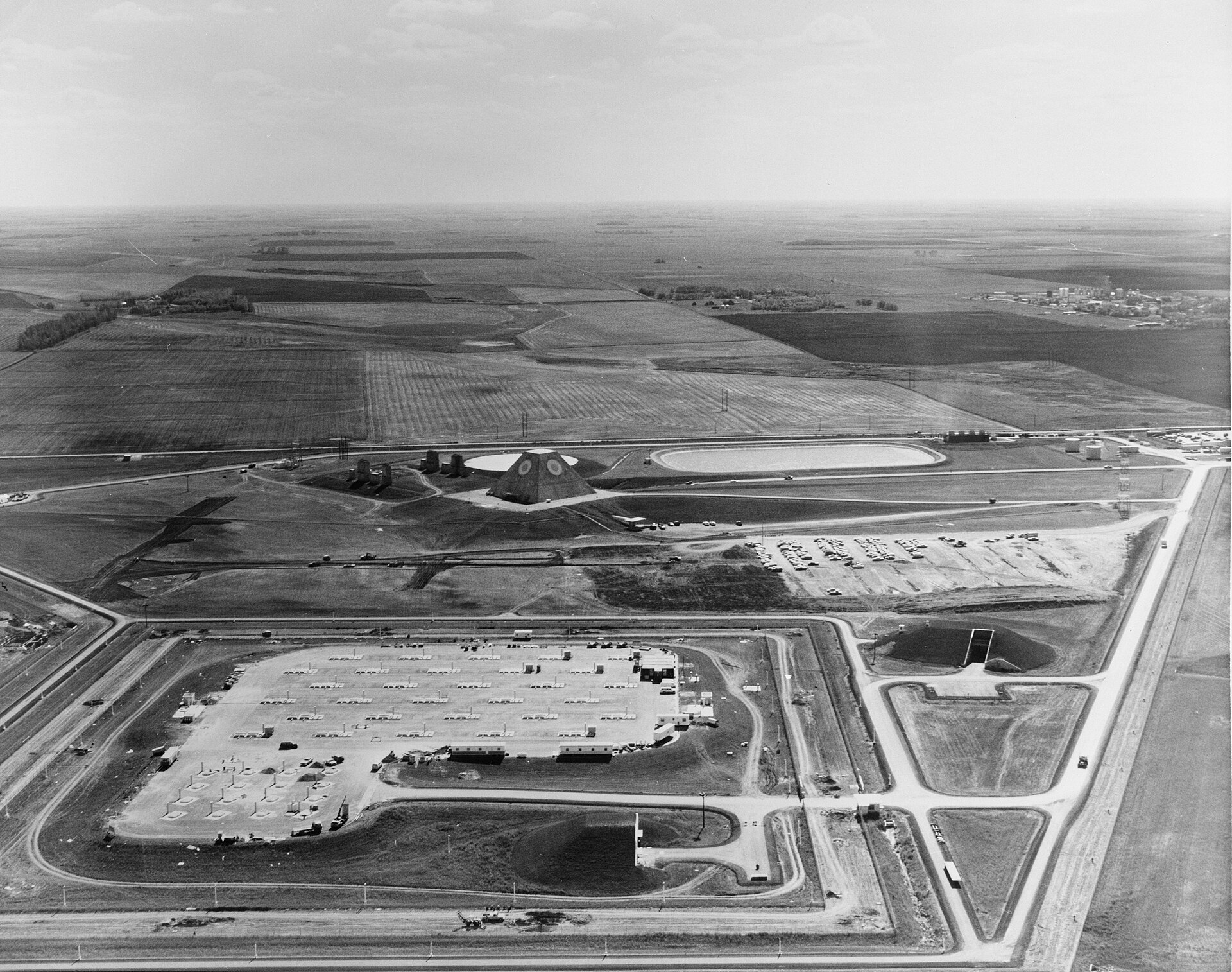
The pyramid was only its most visible piece. An aerial view makes the larger arrangement easier to understand.
Who was Stanley R. Mickelsen?
The complex’s name honored Lieutenant General Stanley R. Mickelsen, a major figure in Army air defense.
An Army historical account of the naming describes the 1974 decision. The designation tied the new missile-defense installation to an earlier generation of air-defense leadership.
Remembering the person behind the name also helps keep the site in context. The pyramid can look like an isolated curiosity in photographs, but it belonged to an organization with its own people, professional history, and strategic responsibilities.
Its appearance may suggest science fiction. Its purpose grew out of real decisions about how to defend military forces during a period of deep international tension.
Did it really operate for only one day?
No. The Army’s operational history records initial operational capability on April 1, 1975, and full operational capability on September 28, 1975.
The latter milestone arrived ahead of the scheduled October 1 target. Political decisions then moved toward termination, but the mission did not end immediately.
The same Army account places the end of the mission in February 1976. It also explains that the system met its design specifications.
Those details matter. A vote or funding decision is not the same event as switching off an installation and completing its withdrawal from service.
The accurate version remains remarkable: an enormous defense project reached full capability, then lost its mission within months. There is no need to compress that history into a misleading one-day claim.
Shutdown was a process
The Army’s account of Operation Rocking Force documents deactivation as an organized undertaking.
That provides a useful way to think about a former military landscape. When the operational purpose ends, the buildings, equipment, security needs, and property responsibilities do not disappear with it.
Later photographs show an apparently quiet complex, but quiet is an outcome, not an explanation. It followed decisions about removing the site from service and managing what remained.
The featured photograph dates to August 2011. It records the pyramid and surrounding structures at that time. It should not be read as a current invitation to enter the property or as evidence that nothing has happened there since.
What happened to the land afterward?
The Army’s property-disposal record describes roughly 600 acres across five parcels: the main Missile Site Radar property and four remote launch sites.
It records sales in 2013. This is another reason to avoid treating the entire former system as a single public ruin. Separate parcels can have different owners and uses.
Bitzero identifies its acquisition of the North Dakota site in 2022 as part of its infrastructure development story. Its materials describe plans tied to the property’s power and security characteristics.
An acquisition and development plan do not prove that every proposed facility is complete. They do establish that the site has a later ownership story beyond abandonment.
Can you visit the pyramid?
Treat the complex as private property. The sources reviewed do not establish regular, unrestricted public interior tours.
If an owner announces an authorized event, verify the date and exact access arrangements directly. Otherwise, respect posted boundaries and avoid stopping or entering in ways that interfere with the property or surrounding roads.
For understanding the place, official histories and archival views offer a better starting point than trespass videos. They explain why the odd structure exists and why its original purpose ended so quickly.
The pyramid survives as a reminder of a particular strategic bet. Its lasting power comes from that contrast: permanent-looking concrete built for a mission that proved surprisingly brief.
Frequently asked questions
Where is the complex?
The main radar site is near Nekoma in northeastern North Dakota.
Was it a missile launch site or a radar station?
The wider complex combined radar and missile-defense facilities, including separate remote launch sites.
When did the mission end?
Army histories place the end of the Safeguard mission in February 1976, after operational milestones in 1975.
Is it open for urban exploration?
No general public exploration permission is established. Obtain explicit authorization before entering private property.
Image credits
Featured image: Troy Larson and Terry Hinnenkamp, CC0. Body image: Historic American Engineering Record, Public domain. Images retain their original framing; dates are identified in their captions or the article.

