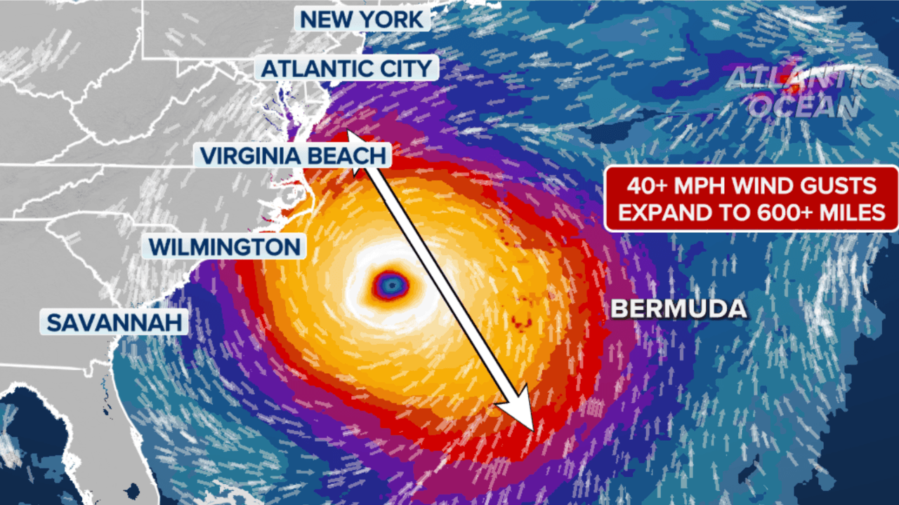
Hurricane Erin, the first major storm of the 2025 Atlantic season, has regained strength as a Category 4 hurricane, forcing evacuations and triggering warnings along the eastern coast of the United States. Authorities are urging residents to stay alert as life-threatening surf and rip currents spread across the region.
A Storm of Rapid Intensification
The National Hurricane Center (NHC) said Erin “explosively deepened and intensified” over the weekend into a Category 5 storm before temporarily losing strength. As of Monday evening, Erin was packing sustained winds of 130 miles per hour while moving east of the Bahamas.
The hurricane’s outer rain bands have already reached the southeastern Bahamas and the Turks and Caicos Islands. Officials in the British overseas territory suspended public services on its largest island and advised residents in vulnerable zones to prepare for possible evacuation. Forecasts suggest up to six inches of rain could fall across the islands, with risks of flash flooding and storm surge.
Widespread Impacts Across the Region
Puerto Rico has already felt Erin’s force, recording more than 80 millimeters of rain in 24 hours. High winds damaged power lines, leaving over 150,000 residents without electricity, though the majority of service has since been restored. Heavy rainfall was also reported in Anguilla, with more than 60 millimeters falling in one day.
Helen Willetts, lead meteorologist for BBC Weather, described Erin as “a major storm” with the potential to bring coastal flooding, wind damage, and dangerous rip currents along its path. “Although at this stage it’s not expected to make a direct hit to land, it will bring considerable amounts of rain and coastal flooding,” Willetts said.
East Coast Prepares for Dangerous Surf
The NHC expects Erin to track between Bermuda and the US East Coast by midweek, remaining a “large and dangerous hurricane” during this time. Along North Carolina’s Outer Banks, authorities have ordered a mandatory evacuation of Hatteras Island, warning that the main highway connecting the island could become impassable due to storm surge and flooding.
Dangerous rip currents are forecast to affect much of the US East Coast. Officials have urged swimmers, surfers, and boaters to stay out of the water until conditions improve. “These storms are very volatile and can make sudden shifts in movement,” said Aarone Sargent, managing director of the Bahamas Disaster Risk Management Authority.
What Comes Next
Erin is not currently forecast to make direct landfall on the US mainland, but forecasters warn that even offshore hurricanes can bring life-threatening hazards. The combination of heavy surf, rip currents, and coastal flooding could persist for days along the Atlantic shoreline.
Residents across the East Coast are advised to monitor local updates and follow official guidance from the Federal Emergency Management Agency (FEMA) and local emergency authorities. With peak hurricane season just beginning, officials stress that preparedness is the best defense against rapidly changing conditions.