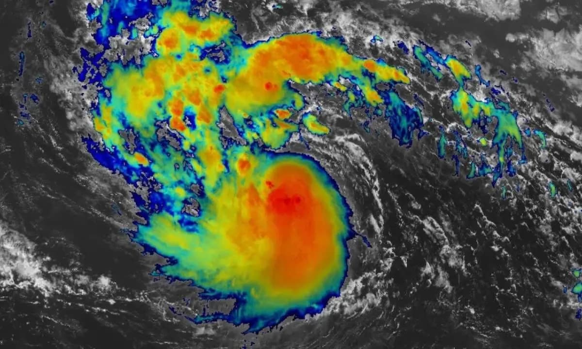
Tropical Storm Erin began as a swirling system in the eastern Atlantic, far from land, but it has quickly become the center of attention for meteorologists and communities across the Caribbean and U.S. East Coast. By Thursday night, Erin was already packing sustained winds of 70 mph, just shy of hurricane strength, and sat about 690 miles east of the northern Leeward Islands. According to data from NOAA aircraft, the storm was “near hurricane strength,” and conditions were primed for it to strengthen further.
⚠ Get Your Message Out Fast During Storm Erin
When severe weather hits, silence costs trust. Share critical updates across major outlets in minutes—before rumors spread.
Send Your Update Now → Be first. Be clear. Be trusted.Forecast models show Erin taking a west-northwest path toward progressively warmer waters, with very little wind shear to slow it down. These are the perfect conditions for rapid intensification, and experts say the storm will likely reach Category 1 hurricane status by Friday.
AccuWeather’s lead hurricane expert, Alex DaSilva, even warned there is a “window of opportunity” for Erin to jump all the way to Category 4 strength over the Atlantic. By Saturday afternoon, the storm is expected to become a major Category 3 hurricane, with the potential to grow larger and more powerful before the weekend is over.
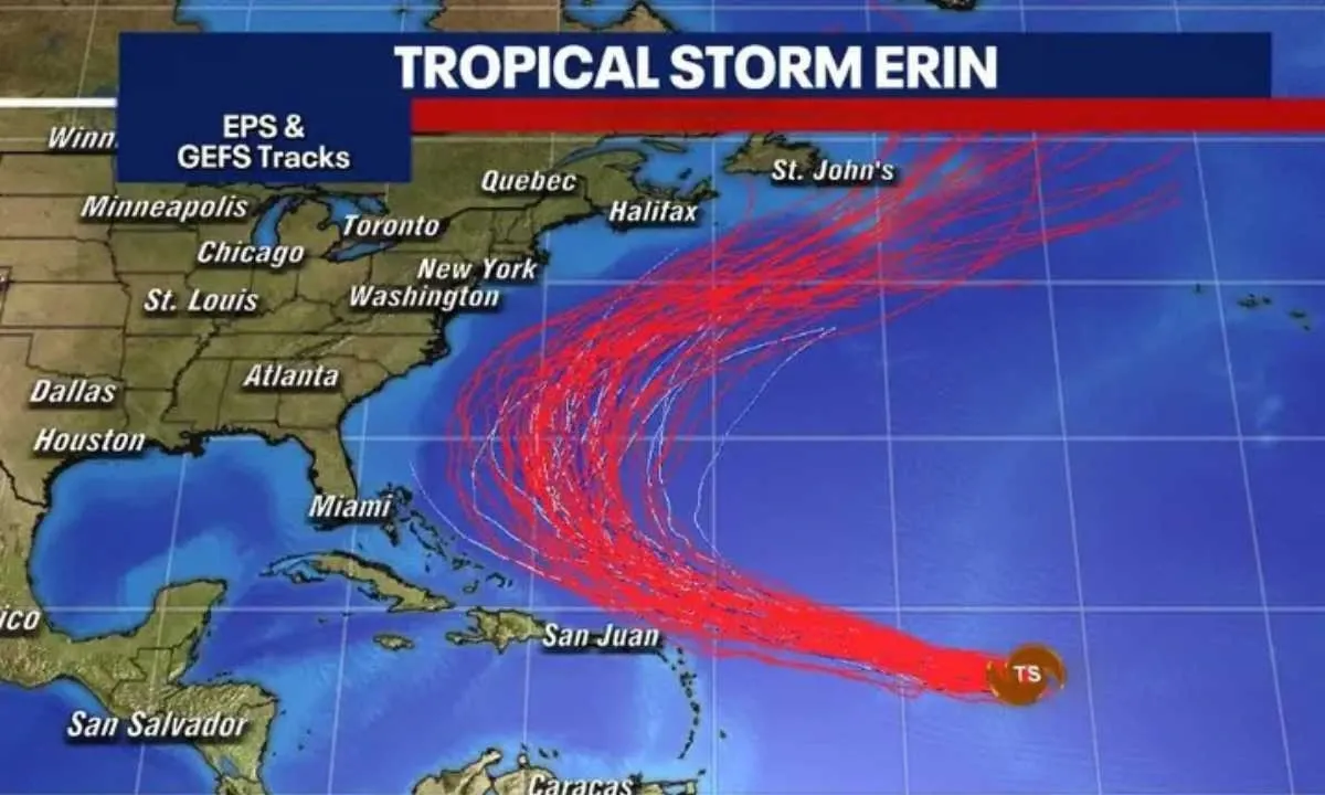
The National Hurricane Center predicts that Erin will be a “large and formidable major hurricane” as soon as Friday. Current forecasts suggest the storm’s core will pass just north of the northeast Caribbean islands, but this doesn’t mean the region will be spared.
Heavy rains, gusty winds, and dangerous surf are likely from Puerto Rico down to Martinique, with the northern Leeward Islands, U.S. Virgin Islands, and British Virgin Islands in the highest risk zone. Tropical storm watches have already been issued for Anguilla, Barbuda, St. Martin, St. Barthelemy, Saba, St. Eustatius, and Sint Maarten. These watches mean winds over 40 mph are possible within 48 hours.
The impacts are not only expected in the form of wind. Forecasters warn of high surf, dangerous rip currents, and bands of heavy rain that could trigger flash flooding. This risk is real—Erin has already left destruction in its wake.
Earlier this week, it slammed Cape Verde’s island of Sao Vicente with torrential rains, strong winds, and flash floods, killing at least nine people. Five more remain missing, and around 1,500 have been displaced. The government there declared a state of emergency in response to the disaster.
Governments and agencies are now mobilizing ahead of Erin’s approach. In an unusual move, California Governor Gavin Newsom announced that his state is deploying resources to Puerto Rico before the storm arrives.
“We’re glad to help coordinate life-saving response to Americans in harm’s way,”
California Governor Gavin Newsom.
FEMA has also confirmed that its teams are already on the ground in Puerto Rico and the U.S. Virgin Islands, staging generators and other critical resources to support local officials.
While the Caribbean braces for impact, the storm’s path beyond the weekend remains less certain. Models show Erin will eventually curve north, guided by a break in high pressure systems between the eastern U.S. and Bermuda. The exact point of that turn will determine whether the U.S. East Coast or Bermuda faces any direct impacts.
For now, the probability of landfall along the East Coast is considered low. Still, forecasters caution that Erin will generate high surf and dangerous rip currents along much of the eastern seaboard next week, regardless of its exact track.
Bermuda is also being told to monitor Erin closely. Depending on when and where the storm turns northward, it could pass close to the islands next week as it continues its journey through the Atlantic.
Erin is already the fifth named storm of this Atlantic hurricane season, which runs from June 1 to November 30. But its rapid growth and potential to become the season’s first major hurricane have made it a standout threat. Over the next several days, all eyes will remain on updated advisories and satellite images as the storm’s track becomes clearer. For those in its path—or even near enough to feel its outer effects—preparation now could make all the difference.
Disclosure: We may earn a commission when you make a purchase through the ads.