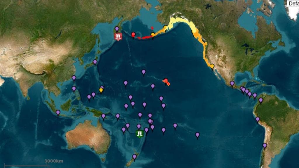
On July 30, 2025, the Earth shook violently beneath the Pacific Ocean near Russia’s far eastern Kamchatka Peninsula. What started as a reported magnitude 8.0 earthquake was soon revised by the U.S. Geological Survey (USGS) to 8.7, and then finally confirmed as a staggering 8.8 magnitude quake. The tremor struck at 8:25 a.m. local time, about 136 kilometers (or 84 miles) from the city of Petropavlovsk-Kamchatsky.
It sent buildings swaying, knocked out power and mobile service, and left parts of the Russian city damaged. While no serious injuries were reported, several people sought medical care, and the aftershocks—some reaching 6.9 in magnitude—only added to the tension.
But the earthquake’s impact didn’t stop at Russia’s borders.
Just minutes after the quake, tsunami warnings rippled across the Pacific like the waves themselves. The Pacific Tsunami Warning Center (PTWC) and local authorities in multiple countries issued urgent alerts, triggering evacuation plans and emergency responses.
The entire U.S. West Coast—from Washington state down to Southern California—was placed under tsunami watches and advisories. Hawaii went into full tsunami warning mode, and Alaska’s Aleutian Islands braced for early wave activity. Sirens wailed across Honolulu, with warnings declaring that urgent action should be taken to protect lives and property.
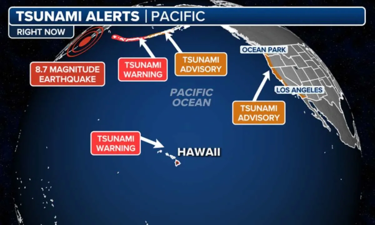
Officials in Hawaii moved quickly. All commercial vessels were ordered to evacuate harbors in Honolulu, and traffic jams quickly clogged Oahu’s streets as residents left the coastal areas to reach higher ground. Honolulu’s tsunami evacuation website crashed under heavy traffic as people rushed to understand where to go and what to do.
The first tsunami wave was expected to reach Hawaii at 7:10 p.m. local time, with warning sirens sounding an hour earlier. The Hawaii Emergency Management Agency posted hourly updates, urging people to take the threat seriously.
In California, the situation developed more slowly. The National Weather Service (NWS) advised that while a full tsunami wasn’t guaranteed, strong currents and dangerous waves were still likely, especially along beaches, harbors, and inlets. The highest forecasted wave was expected to hit Crescent City, potentially reaching between 2.9 to 5.4 feet.
Other areas along the coast—such as Port San Luis, Fort Bragg, and Santa Barbara—were predicted to experience waves ranging from 0.7 to nearly 4 feet. Meteorologists noted that the timing of the tsunami’s arrival would overlap with the daily high tide, which could worsen coastal flooding.
Similar warnings reached the coastlines of Oregon and Washington. Cities like Port Orford and Brookings in Oregon, and Westport and Moclips in Washington, were told to expect waves just over a foot in height. Though small in appearance, officials reminded the public that even waves under a foot can carry dangerous force.
In fact, a meteorologist recalled how, back in 2011, a man was swept out to sea near Crescent City while photographing a tsunami. That served as a powerful reminder of how deceptive these events can be.
Further north, Alaska’s Aleutian Islands were the first U.S. territories expected to see wave activity. Warnings included precise times for possible wave arrivals—Shemya Island at 4:46 p.m., Adak Island at 5:46 p.m., and Saint Paul Island at 7:06 p.m. Forecasts indicated that wave heights could vary, with places like Adak possibly seeing up to 2.2 feet.
But it wasn’t just the U.S. responding. Japan’s Meteorological Agency upgraded its earlier advisory to a full tsunami alert for the Pacific coast, warning of waves up to 3 meters (about 10 feet) and urging residents to stay away from the shore. At Ishinomaki Port, waves of up to 50 centimeters (1.6 feet) were measured. While these initial waves weren’t massive, Japan warned that the second or third waves could be stronger.
Elsewhere in Asia, the Philippines advised residents along the Pacific coast to avoid beaches as waves under 1 meter (about 3.2 feet) were expected. In China, authorities expected waves of 30 centimeters to 1 meter to hit parts of the eastern seaboard. Even Peru’s navy issued tsunami warnings for its coastal regions, saying the situation would remain under constant watch. Mexico’s navy also warned of strong currents and urged people to stay away from Pacific beaches, spanning from Baja California in the northwest to Chiapas in the south.
The Pacific Islands weren’t spared either. Alerts were issued for Guam, Rota, Tinian, and Saipan in the Northern Mariana Islands. All were told to prepare for possible wave activity and dangerous coastal conditions.
Meanwhile, U.S. President Donald Trump took to his platform, Truth Social, to urge Americans to follow local evacuation orders and stay safe. Emergency teams across the Pacific Rim coordinated their responses, constantly updating the public with the latest developments.
To make sense of all the alerts, the National Weather Service explained the four levels of tsunami messaging:
- Tsunami Warning: Take immediate action; flooding is expected or happening.
- Tsunami Advisory: Strong waves or currents are expected; stay out of the water.
- Tsunami Watch: A tsunami is possible; be alert.
- Tsunami Information Statement: An earthquake occurred, but there’s no tsunami threat yet.
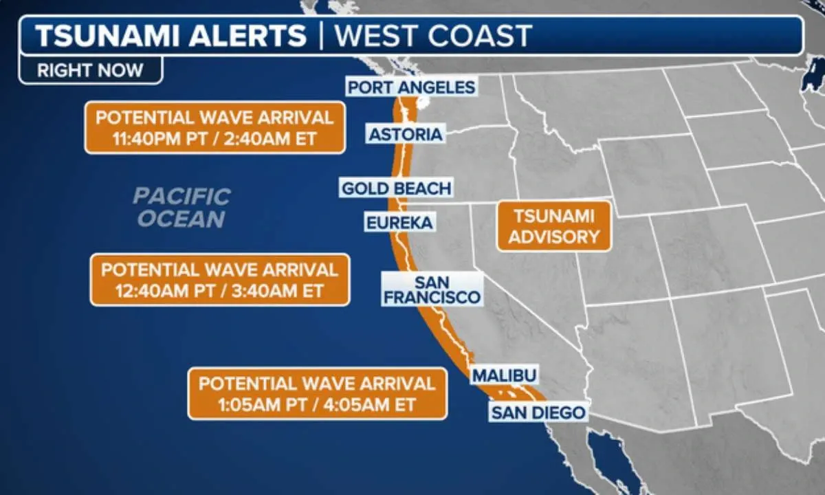
The Maximum Height of Potential Tsunami Waves as Forecasted by the National Tsunami Warning Center
California
- Crescent City in Del Norte County faces the highest risk, with waves forecasted between 2.9 to 5.4 feet. This location has a history of vulnerability, including fatal incidents in 2011 when a man was swept into the sea while photographing a tsunami tsunami.govLos Angeles Times.
- Port San Luis in San Luis Obispo County is expected to see waves up to 3.8 feet Los Angeles Times.
- Other parts of the California coast—such as Fort Bragg, Monterey, Santa Barbara, Newport Beach, and La Jolla—are predicted to have maximum wave heights of 1.4 feet or less, with many areas under one foot Los Angeles Times+1newsweek.com+1.
Oregon & Washington
- Wave forecasts in Oregon include Port Orford at 1.0–1.8 feet, Charleston at less than 1 foot, and Brookings at 0.8–1.5 feet newsweek.comSan Francisco Chronicle.
- In Washington, coastal areas like Neah Bay, Long Beach, Westport, Port Angeles, Port Townsend, and Bellingham are all expected to see waves of less than 1 foot, although strong currents still present serious hazards Los Angeles Times.
Alaska (Aleutian Islands)
- Areas in the Aleutian chain—including Shemya Island, Adak Island, and Saint Paul Island—are projected to experience wave heights up to 1.2 to 2.2 feet in Adak, and less than one foot elsewhere tsunami.govnewsweek.com.
Hawaii
- Hawaii is under a full tsunami warning, with serious risk of waves ranging between 6 and 10 feet high. The first wave was expected to arrive around 7:17 p.m. HST. Evacuations and harbor closures were ordered statewide
As of now, the situation remains fluid. With the threat of multiple wave arrivals and high tide timings, people in all affected areas are urged to stay alert, follow official updates, and avoid the coastline. The earthquake has already left its mark on the world—how far its effects will reach is still unfolding.