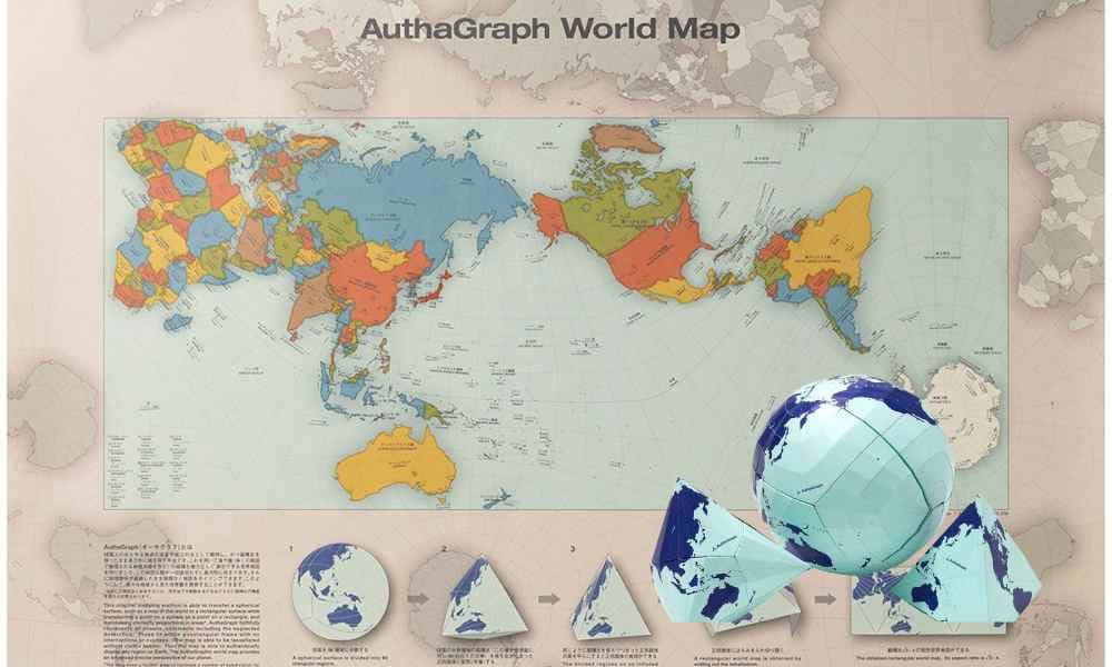
Have you ever wondered how we can fit the whole world onto a flat piece of paper? It’s a tricky challenge that mapmakers have been trying to solve for a long time. But now, there’s a map called AuthaGraph that claims to be the most accurate one yet! Let’s find out what makes AuthaGraph special and if it’s really the best map out there.
AuthaGraph is not like the maps you usually see. Hajime Narukawa invented this map projection for the world. Instead of stretching and squishing the land, it uses a clever method. It divides the Earth into 96 pieces and turns them into triangles.
View this post on Instagram
The triangles are then put together into a tetrahedron, like a puzzle to make the map. This way, AuthaGraph tries to show countries and continents in their correct shapes and sizes. The map projection reduces the distortions of different shapes. This impressive map has won the Good Design Award in Japan.
One big problem with traditional maps is that they make some places look much bigger than they are. For example, in some maps, Greenland appears to be the same size as Africa, even though Africa is actually much larger.
View this post on Instagram
AuthaGraph tries to fix this by showing the sizes of places more accurately. So, countries near the North Pole, like Greenland or Russia, don’t look gigantic compared to countries near the equator. Japanese National Museum for Emerging Science and Innovation uses this map projection as its official mapping tool.
AuthaGraph’s accuracy can be helpful in many ways. It can be used by city planners, people who manage logistics (like shipping and transportation), and even during disasters. Also, because AuthaGraph shows land areas equally, it can be used to talk about important environmental issues. It helps us see the distribution of land and understand why places like Africa or South America are significant.
View this post on Instagram
Conclusion:
While we can’t say for sure if AuthaGraph is the absolute best map ever, it’s a unique and interesting approach. It tries to solve the challenge of accurately showing our planet on a flat map, and that’s pretty cool! Whether or not AuthaGraph becomes the most popular map, it makes us think about the accuracy of traditional maps and opens up exciting conversations among mapmakers, geographers, and curious minds like yours!